Image products
Product levels
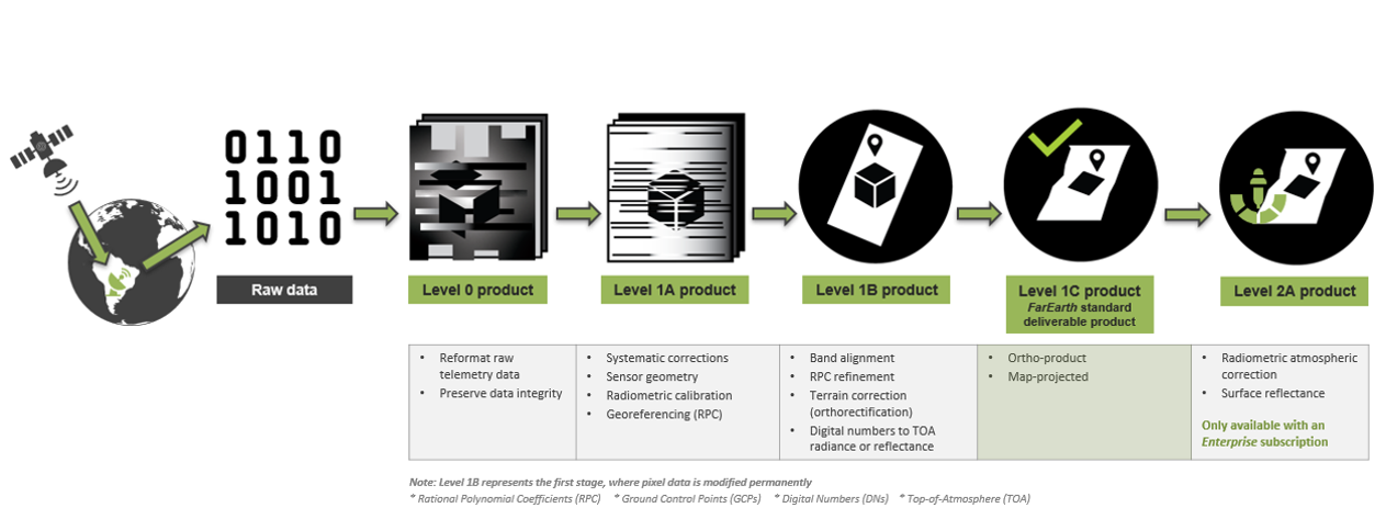
Satellite image data received from a ground segment undergoes multiple processing stages to produce usable image data products. Each stage provides products with varying amounts of data manipulation and advancement toward a usable image.
The processing level and output data formats can be tailored to operational requirements. FarEarth uses the following definition for our product levels, read more in our Product Levels info sheet.
STAC compliant
- All FarEarth products are stored in the FarEarth Archive. The product file (
product.json) is STAC v1.0.0 compliant - The FarEarth Catalogue allows querying the Archive using the STAC-compatible OpenAPI RESTful interfaces
- PySTAC is a popular library used to interact with STAC-compatible catalogues
For more examples on how to use the STAC APIs, refer to our API documentation.
Image formats
Level 0
- Level 0 products are stored in HDF5 format
- All pixels, metadata and ancillary data are stored in a single HDF5 file
- Basic metadata and ancillary data, as well as a thumbnail preview image in PNG format, are provided alongside the HDF5 file
Level 1 & Level 2
- Level 1 products, including 1A, 1B and 1C, as well as Level 2A products, are stored as Cloud-optimised-GeoTIFFs (COGs) by default. It can also be provided as JP2000 files
- The metadata is stored separately in a STAC-compliant product file
- The pixel datatype is either INT-16 (for digital numbers) or FLOAT-32 for calibrated data
- For more detail, refer to our Format Books
Scene IDs and file naming conventions
All products in FarEarth follow a similar file-naming convention. If required, alternative filenames can be configured to better suit your environment.
Scene IDs
The convention used for scene IDs: <spacecraft>_<instrument>_<start>_<end>_<type>_R<row>C<column>
| Field | Description |
|---|---|
spacecraft | The name of the spacecraft (example, TRUBIT-1) |
instrument | The name of the instrument(s) (example, VNIR). If multiple instruments are used, they are separated with an underscore (example, VNIR_TIR) |
start | The start time of the image (when the instrument was switched on), in UTC. See also time-format below |
end | The end time of the image (when the instrument was switched off), in UTC. See also time-format below |
type | The product type in short-form. Examples are L1C (Level 1C), L2A (Level 2A) or NDVI |
row | The row-number for scenes extracted from a larger acquisition |
column | The column-number for scenes extracted from a larger acquisition |
Example: TRUBIT-1_VNIR_20250101T120015_20250101T120021_L1C_R1C2:
- Satellite: TRUBIT-1
- Instrument: VNIR
- Imaging time: From 12:00:15 UTC to 12:00:21 UTC, on 1 January, 2025
- Product type: Level 1C
- Row 1, column 2
Filenames
The convention used for filenames is: <scene-id>_<descriptor>.<extension>
| Field | Description |
|---|---|
scene-id | The structure of the scene ID is described above |
descriptor | The descriptor distinguishes specific files from another. For example, the Red image band will have a descriptor of "RED" |
extension | The extension indicates the format of the file, such as "tif" for GeoTIFF files, "json" for GeoJSON files, etc. |
Examples:
- TRUBIT-1_VNIR_20250101T120015_20250101T120021_L1C_R1C2_product.json (scene product file in STAC format)
- TRUBIT-1_VNIR_20250101T120015_20250101T120021_L1C_R1C2_RED.tif (red band in GeoTIFF format)
- TRUBIT-1_VNIR_20250101T120015_20250101T120021_L1C_R1C2.geojson (metadata in GeoJSON format)
Time format
All time-formats follow this structure: yyyyMMdd'T'HHmmss. The month and day values are zero padded (example, 06).
- Example:
20260620T131020(20 June, 2026, at 13:10:20)
Product metadata
The content of a product's metadata depends on the product type and processing level.
Level 0
- All metadata is contained within the HDF file
Level 1 and Level 2
The main metadata files associated with Level 1 and Level 2 products are provided in the table below. Follow the links to the detailed documentation in our Format Books.
| File | Content | Format book |
|---|---|---|
.geojson | GeoJSON metadata file containing most of the important information | Level 1C product metadata |
_ANGLES.json | JSON file containing solar and incidence angles | Level 1C angle metadata |
_GVER_REL.json | JSON file containing relative geometric accuracy results | Level 1C geometric: relative |
_GVER_ABS.json | JSON file containing absolute geometric accuracy results | Level 1C geometric: absolute |
_POINTING.json | JSON file containing disparities (geolocation errors) between raw, systematic and precision refined image products | Level 1C geometric pointing metrics |
_SPECTRAL_RESPONSE.csv | CSV file containing relative spectral responses for each band | |
_NAVATT.json | JSON file containing all navigation and attitude information for the scene | |
_SCANTIME.json | JSON file containing the timestamps for each imaging line, separated per band |
Product quality reports
FarEarth generates Quality Reports for Level 0, Level 1C and Level 2A products. These reports can be viewed online in the Catalogue, and downloaded as PDF.
Level 0
The Level 0 Quality Report focusses on data quality:
- Pixel timing information
- NavAtt behaviour before, during and after imaging
- Dropped or missing pixel data
The above is used to investigate the satellite's pointing and flight behaviour, as well as data acquisition quality. This can be very useful during the satellite commissioning phase.
Read the Level 0 product Quality Report blog for more information.
Level 1C
The Level 1C product Quality Report focuses on geometric and geolocation accuracy:
- Absolute geolocation accuracy, measured against Sentinel-2 reference data
- Relative geolocation accuracy, measured between the bands within the image product
Read the Level 1C product Quality Report blog for more information.
Typical product quality
Product quality depends on the quality of the input data.
Geometric accuracy
- Absolute geolocation: sub-pixel
- Typically, offsets are less than 1 pixel (CE95) from the reference image
- When using Sentinel-2 as a reference, this means an accuracy in the range of 10 meters
- Band-to-band alignment: less than 0.3 pixels (CE95)
- With bands of different resolutions, this would mean sub-pixel co-registration of the lowest resolution band
Radiometric accuracy
- Absolute top-of-atmosphere (TOA) error in radiance: 5-10%
- Inter-band relative radiometric uncertainty: better than 5% consistency across bands
- Multi-temporal relative radiometric uncertainty: better than 2% over time for any given spectral channel
To maintain an optimal geometric model, we automatically split long acquisitions into roughly square scenes
How to achieve maximum product quality
We use several external references during processing, such as Sentinel-2, Landsat, or client-provided. The best product quality is achieved if the input data is of good quality. Below is a guideline of the input needed to produce excellent products. We understand input data is not always ideal. Do not worry, FarEarth can still produce products.
- Your input data should preferably be free of haze with less than 10% cloud cover
- Scenes over polar regions or oceans will have less accurate geolocation because of a lack of reference data
- Scenes with visible features such as roads and rivers have better geolocation accuracy
- Large water bodies can impact the accuracy
How to achieve maximum product quality Level 2A bottom-of-atmosphere products
- Reflective bands: images must include blue, green, red, NIR and preferably SWIR bands
- Emissive bands: images must include red and NIR bands, and preferably two emissive bands